Google Transit

Google Transit Vancouver Announcement Recap
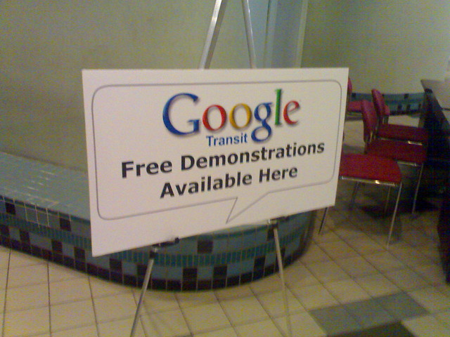
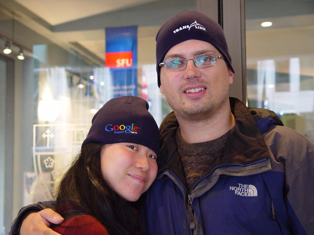
Google Transit and TransLink announced last week that they are collaborating in displaying Vancouver's transit routes and times overlayed on Google Maps, and I was there to watch as Headway Blog writer and Google software engineer Joe Hughes demonstrate its features. He presented it very well, framing the service around stories of people hearing about an event and figuring out how to get there. One example was of a UBC student hearing that M.I.A. was coming to town playing at the Commodore Ballroom. She (the student) would locate the Commodore Ballroom on a map, click on the more info link to see that it was the right venue, then get directions from her campus, first for driving but then, a click away, transit information. Gordon Price documented Joe's story about the Giant Crab of Doom, which illustrated how Google Maps users have added value to the service. Paul has photos from the launch, and Karen (pictured below with me and our cool Google/TransLink swag) has noted that Google Transit may not incorporate the subtleties people learn from experience.

Karen and I Wearing Our TransLink/Google Transit Hats

I talked to Joe afterwards and asked him the most technical questions I could think of, like: will there be an API? (sort of, it happens through the feed, which individual transit agencies decide to release); what format is the feed in? (I mistakenly believed it was XML, but it's CSV, designed to make it easier for transit agencies to produce); what about a microformat? (there's nothing stopping anybody from starting one on the wiki); and how about Google Bike maps? (I might be getting his answer wrong, but he said it was good idea if a little more difficult, since many bike routes are on low-traffic streets and trails). Those who stuck around got some hats, slightly too small for my extremely large head, and I managed to convince the communications rep to let me have her lanyard. JMV took some photos—but hasn't posted them yet?—including the one you see to the right, and I finally got to meet Paul Hillsdon, he who created the excellent South of Fraser transit and Surrey cycling initiative documents.

Karen and I Wearing Our TransLink/Google Transit Hats

Which we got from the launch announcement at SFU Harbour Centre. Paul, Karen, and Gordon were there. So was I! Photo taken (and copyright) by JMV.

tags: , , , , , , , , , ,
Flickr icon for miss604
Submitted by miss604 on Wed 2007-11-07 12:37 #

awesomely cute and geeky :)

Flickr icon for roland
Submitted by roland on Wed 2007-11-07 21:39 #

amen!

Flickr icon for sillygwailo
Submitted by sillygwailo on Thu 2007-11-08 11:47 #

:)

The above comments will not display in the recently updated section because they are syndicated directly from the Flickr photo.

group: Vancouver Transit
Karen reviews Google Transit for Vancouver
There’s a sense of prioritization in the way decisions about how to get somewhere that’s different for every trip and person: what’s an express route, what bus will save me from walking as much, what buses are less busy at certain times of day, where’s Canada Line construction or a CN Rail train going to throw a complete wrench in things, what buses will pass by places I want to go, what buses can take my bike.
My notes at Jaiku of the TransLink/Google Transit launch/demonstration
Much more to report, including meeting and talking with Joe Hughes of Google.

Google Transit for Vancouver's TransLink Launches Officially Tomorrow

The other day, Paul Hillsdon tantalized us combination transit geeks and web geeks with a graphic showing Google Transit and TransLink together, implying that Vancouver's transportation authority was going to have their routes and time schedule included in Google's maps. TransLink sent me an invitation (to an email address that I don't even use), and I posted an event listing on Urban Vancouver for the official launch, which happens tomorrow (Thursday, November 1st) at 10:30 AM at SFU's Harbour Centre Fletcher Challenge Theatre. I'll be there along with my citizen journalism and transit fan buddies documenting the event.

It turns out that Google Transit Vancouver is live: if you visit http://www.google.com/transit and type in directions for two points in Vancouver, you'll get reasonably good routes. Some are reasonable, like getting from Port Moody to Waterfront Station (it recommends the 160 in the afternoon, and the West Coast Express in the morning, though it shows it as a straight line hovering over Burnaby and Vancouver). Some aren't so great: getting from my work to UBC they recommend taking the #4 or the #8 all the way, when I would have suggested getting to Broadway and Granville via the multiple ways to do that, then take the #99 B-Line express bus to the university campus. But still, did you see that? I can now directly link to transit directions so that I can share it online. Also, you really have to force it to get a route that includes SkyTrain, which is usually faster from point to point along its route than a bus. I also found it difficult to get directions from one place name (without an address, e.g. GM Place or the various combinations of "Brentwood Station", "Brentwood Mall", and "Brentwood Town Centre"). I also hear it's hard to get a route that recommends the SeaBus. I still love you, SeaBus.

Walking indicator in Google Transit

There are nice touches, like little indications for walking, since taking transit means you're not walking from a parking spot but rather from wherever you're let off. I'd like the ability to change directions by dragging around or suggesting a route # that you might already know of, and having Google learn from what transit users contribute. Every day while riding SkyTrain I marvel at how many people take it and how much route knowledge they have based on information they get from TransLink coupled with trial and error. (There's nothing saying that the fast way to go is always the best way: I often go out of my way to walk farther and take a longer commute so that I can take both SkyTrain lines either to work or back home. In other words, I'd like a button called "optimize route for fun".) This has already been requested, but I'd also like Google Maps and its direction functionality to include bike maps for those whose commute involves that mode of transportation, and integrate it with driving and transit directions. Who says you can't bike to the SkyTrain station, lock your bike there—or take it with you—and take the train to your meeting?

This is something I've been wanting for almost two years since Google launched Transit for the Portland, Oregon area. At the time I even asked TransLink if they had plans to integrate with Google, and the answer was no. Now they have, and I commend both TransLink and Google for working together and getting this done. I'm looking forward to seeing what's possible with getting the information out of Google (e.g. a conference recommending routes from downtown and their airport and linking to them or including them inline on the conference website), and the increased ease of use over TransLink's own trip planner. Like TextBus, I anticipate using this at least twice a week.

Should

I'm playing around with Should Do This today, another offering from the Robot Co-op, makers of 43 Things, 43 Places, and 43 People (but not 43 Thongs). Common Craft is using this as their suggestion box, and I've added suggestion boxes for TransLink and KEXP. (I represent neither.) A few of them were originally blog posts, that is, my having gone through my blog searching for the word 'should' and adding it to Should Do This. People and organizations often do the right thing because it also solves a problem for them or they benefit from it directly, though, so it might be more useful for TransLink if I told them why they should hire a social media/community manager to blog and respond to others' blogs and include their trip planning data in Google Transit. You can find my 'shoulds' using the usual handle, which you can subscribe to via RSS.

Google adds Eugene, Honolulu, Pittsburgh, Seattle and Tampa to their Trip Planner
Vancouver's TransLink is not on the list, but they published the specification in case they wanted to do so (it'd be hilarious if virtual communities like Second Life made feeds, just for the heck of it).

Pages