Google Maps

Vancouver Magazine's Instant Office Cafés on a Google Map

Today Scout Magazine and Beyond Robson linked to my Google Map of Andrew Morrison's 50 favourite places to eat in Vancouver. Also today, Vancouver Magazine published a list of 5 cafés in Vancouver (and North Vancouver) where you can setup shop for a virtual office, and they too did not include a map of any kind. Since there are only 6 places listed, this time I entered the addresses in Geocoder.ca, made a spreadsheet, converted it to KML, and imported it into Google Maps without any programming. The result (shorter URL) is below, with phone number, address and hours but without the writeup from Vancouver Magazine. It took me half an hour to create.

View Instant Office in a larger map

Andrew Morrison's 50 Favourite Things to Eat & Drink in Vancouver on a Google Map

Summary

Rob pointed to Andrew Morrison's favourite things to eat & drink in Vancouver. After a few hours of programming and manual data manipulation, I was able to provide a Google Map of Andrew Morrison's 50 favourite things to eat in Vancouver that Rob requested.

Unabridged

Sitting around all week looking for a programming task to sink my teeth into, Rob Vanmega posted a link to Andrew Morrison's favourite things to eat & drink in Vancouver. Not knowing much about the food scene in Vancouver, and not identifying as anything resembling a foodie (is there a word for us?), I nevertheless took up Rob's challenge to make it into a Google Map. Seeing this as an opportunity to scrape off some of my programming skills' rust, I set about to parse the list into a format that Google My Maps could import. It was way harder than it needed to be.

View Andrew Morrison's 50 Favourite Things to Eat & Drink in Vancouver in a larger map

Thankfully, Andrew Morrison crafted his list in a consistent, structured format. Not semantic by any means, but he wrapped each restaurant name and food item in <strong> elements, and the address, phone and website were all inside parentheses. Using TextMate to inspect the HTML list (surrounded by paragraph tags), and futzing around with a couple of regular expressions, I removed the surrounding text and get to the heart of the data. A couple of passes later, the data went into a CSV file and, after some manual manipulation by both Rob and myself, I came out with a decent set of information. Unfortunately, Google Maps wouldn't work with just the address, but had to use longitude and latitude.

That's where Geocoder.ca came in. With a useful, not free (but very cheap) API, I could feed in all 50 requests and, after a couple of test runs, got the points on the map. After reformatting the CSV (yet again), I piped it through a CSV to KML converter (a cross-platform application that violates quite a few Mac OS X interface tenets) and imported the resulting file into a custom Google Map.

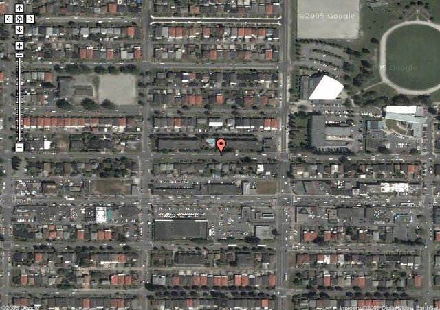
The result of all that work, about 3 hours worth of manual manipulation, programming and converting, we have a Google Map of Andrew Morrison's 50 favourite things to eat in Vancouver. I can't emphasize how much that this is a beta version of the map, since I haven't verified that every location is correctly situated. Feedback is welcome: send me a note if you notice something amiss, and I'll either correct it or add you as a collaborator.

Rob said in his link that “if someone lays this over a Google map, I’ll happily hit all 50 things by year’s end.” He has just over two and a half months.

Patterson Explorer

Yesterday afternoon, needing some exercise and fresh air having spent Saturday indoors, I walked around the neighbourhood surrounding Patterson Station in Burnaby as part of the recommended walks in SkyTrain Explorer by John Atkin. Getting there by bike instead of SkyTrain was the main difference from the others I've taken, cycling down Gilmore, the Sea-to-River Bikeway leading along Patterson, it turns out, right to my destination. I locked my bike up at the station and proceeded on foot, with my GlobalSat DG-100 GPS logger in hand, taking photos with my RebelXTi. You can see the set in Flickr, as well as the map made out in Yahoo! Maps (zoom in a couple of times to see in more detail where I took the photos). I also mapped the walk out in Google Maps, since Atkin's directions were a little confusing initially.

Patterson

A couple of other notes: the switch to daylight savings time made for some mislocated photos. I'm not sure if it was the camera or the GPS unit which had the hour ahead, and luckily GPSPhotoLinker has a button to view where individual photos fit on the map, aiding in discovering this fact. God may strike me down for this, but I manually edited the GPX file that the DG-100 exports via its Windows-only utility, moving all the hours (all in GMT) back one hour. The map on Flickr is a fairly good representation of the houses in the neighbourhood appear.

Some discoveries: Patterson has two entrances, which I didn't know until visiting it. One closer to Burnaby's Central Park, and one above the bus loop. Also, I'm pretty sure that the house 5575 Jersey I photographed is not the same 5575 Jersey that Atkin mentions in his book. He says it's “a fabulous house which is almost lost from view because of the overgrowth of vegetation around it.” Either someone removed the vegetation or someone removed the house.

Needing a short break biking back home, and to make it officially an exploration worthy of the book's name, I hopped on a SkyTrain for one stop from Gilmore Station to Brentwood Town Centre Station.

Google Transit for Vancouver's TransLink Launches Officially Tomorrow

The other day, Paul Hillsdon tantalized us combination transit geeks and web geeks with a graphic showing Google Transit and TransLink together, implying that Vancouver's transportation authority was going to have their routes and time schedule included in Google's maps. TransLink sent me an invitation (to an email address that I don't even use), and I posted an event listing on Urban Vancouver for the official launch, which happens tomorrow (Thursday, November 1st) at 10:30 AM at SFU's Harbour Centre Fletcher Challenge Theatre. I'll be there along with my citizen journalism and transit fan buddies documenting the event.

It turns out that Google Transit Vancouver is live: if you visit http://www.google.com/transit and type in directions for two points in Vancouver, you'll get reasonably good routes. Some are reasonable, like getting from Port Moody to Waterfront Station (it recommends the 160 in the afternoon, and the West Coast Express in the morning, though it shows it as a straight line hovering over Burnaby and Vancouver). Some aren't so great: getting from my work to UBC they recommend taking the #4 or the #8 all the way, when I would have suggested getting to Broadway and Granville via the multiple ways to do that, then take the #99 B-Line express bus to the university campus. But still, did you see that? I can now directly link to transit directions so that I can share it online. Also, you really have to force it to get a route that includes SkyTrain, which is usually faster from point to point along its route than a bus. I also found it difficult to get directions from one place name (without an address, e.g. GM Place or the various combinations of "Brentwood Station", "Brentwood Mall", and "Brentwood Town Centre"). I also hear it's hard to get a route that recommends the SeaBus. I still love you, SeaBus.

Walking indicator in Google Transit

There are nice touches, like little indications for walking, since taking transit means you're not walking from a parking spot but rather from wherever you're let off. I'd like the ability to change directions by dragging around or suggesting a route # that you might already know of, and having Google learn from what transit users contribute. Every day while riding SkyTrain I marvel at how many people take it and how much route knowledge they have based on information they get from TransLink coupled with trial and error. (There's nothing saying that the fast way to go is always the best way: I often go out of my way to walk farther and take a longer commute so that I can take both SkyTrain lines either to work or back home. In other words, I'd like a button called "optimize route for fun".) This has already been requested, but I'd also like Google Maps and its direction functionality to include bike maps for those whose commute involves that mode of transportation, and integrate it with driving and transit directions. Who says you can't bike to the SkyTrain station, lock your bike there—or take it with you—and take the train to your meeting?

This is something I've been wanting for almost two years since Google launched Transit for the Portland, Oregon area. At the time I even asked TransLink if they had plans to integrate with Google, and the answer was no. Now they have, and I commend both TransLink and Google for working together and getting this done. I'm looking forward to seeing what's possible with getting the information out of Google (e.g. a conference recommending routes from downtown and their airport and linking to them or including them inline on the conference website), and the increased ease of use over TransLink's own trip planner. Like TextBus, I anticipate using this at least twice a week.

My Bike Commute is 10.8 KM One Way, 8.5 the Other Way

You know how people exaggerate the olden days by saying they had to walk to school uphill both ways? Well my biking commute is almost like that: on the way to work it's downhill most of the way save for an uphill climb at Lakewood Drive, where on the way back it's uphill approaching Commercial, then downhill after Renfrew and then back uphill, then, saving the worst for last, a steep uphill climb at Boundary and Union in Burnaby. Like Roland, I drew my bike route on Google Maps, but I drew both my to and from work routes. (To work is in red, from work is in blue.) According to Google Calculator, my commute to work is 10.8 KM, and 8.5 KM back home. (I typed in "6.71 miles in kilometers" and "5.31 miles in kilometers" and rounded off the answers.) Because there are more hills on the shorter route, both directions take about the same time, from 45 minutes to an hour each. Two Google maps after the break.

View Larger Map

View Larger Map

As you can see, the route to work takes me next to Burrard Inlet and underneath the Second Narrows Bridge, technically over the train bridge and under the road bridge. It therefore takes me near boats and trains, and sometimes big ocean liners.

Those serious about biking should pick up the paper copy of the TransLink biking map. It's very detailed, with many types of bike routes—on street, off street, and alternate routes, with hills and caution areas noted.

The Greater Toronto Area vs. the Greater Vancouver Regional District
Using Google Maps to compare each city's downtown cores, major downtown parks and one of each city's suburbs.
This meme will only get old when Paris Hilton does it.
My apartment and neighbourhood, as seen from space

Old photo, as the old Safeway and crackhouses (see notes) can attest.

tags: ,
Submitted by deleted on Tue 2005-04-05 09:51 #

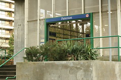
Ooh, rich people can live in former crack houses next to porn shops? How glamourous!

Flickr icon for sillygwailo
Submitted by sillygwailo on Tue 2005-04-05 20:41 #

There used to be a nudie bar just west (i.e. to the left) of the area photographed, but they closed it down and replaced it with...a liquor store.

Flickr icon for sillygwailo
Submitted by sillygwailo on Tue 2005-04-05 21:21 #

Looks like Matt had the idea to annotate his (old) neighbourhood before I did. Another case of great minds think simultaneously I guess.

The above comments will not display in the recently updated section because they are syndicated directly from the Flickr photo.

Flickr icon for sillygwailo

sillygwailo added a note: public library

Flickr icon for sillygwailo

sillygwailo added a note: workout gym and swimming pool

Flickr icon for sillygwailo

sillygwailo added a note: Safeway grocery store, pre-demolition. There is currently a new, bigger one with underground parking at this location.

Flickr icon for sillygwailo

sillygwailo added a note: old high school, now adminstrative/volunteer centre with basketball gym

Flickr icon for sillygwailo

sillygwailo added a note: elementary school with gravel field

Flickr icon for sillygwailo

sillygwailo added a note: porn store and dim sum restaurants (two separate businesses!) at street-level; five-pin bowling alley on the second floor

Flickr icon for sillygwailo

sillygwailo added a note: convenience store

Flickr icon for sillygwailo

sillygwailo added a note: convenience store

Flickr icon for sillygwailo

sillygwailo added a note: convenience store

Flickr icon for sillygwailo

sillygwailo added a note: liquor store

Flickr icon for sillygwailo

sillygwailo added a note: still-undeveloped property

Flickr icon for sillygwailo

sillygwailo added a note: still-undeveloped property

Flickr icon for sillygwailo

sillygwailo added a note: crackhouses, now demolished to make way for rich-people's condos

Pages