


One Week Documenting My World With a Nokia N95
Posted by Richard on Wednesday, 3 October 2007Along with Kris, Roland, Dave, and Rebecca, I'm participating in a week-long Simon Fraser University research project centered around social media and the Nokia N95, a feature-rich mobile phone that takes amazing photos, acts as a media (video and audio) player, and tracks my movements. After two days of playing around with it, I've walked around my neighbourhood, taken video of trains, mapped out my morning commute to work and the full length of the 101 bus from 22nd Street Station to Lougheed Station. Bus routes are boring, I know, since they're already well-documented by the people that operate them, but I endeavor to accurately map my bike route using satellite technology, rather than draw it imprecisely by hand based on memory.
Ideally I'd be using some of the location tools built for Drupal to map out my adventures on my site using external services like Google Maps or Google Earth. Using these tools, either Drupal or the external services, would then spit out RSS and other XML-based feeds so that others can take the information and remix it somehow. In fact exactly a year ago today I wrote (Re-)Documenting My World With Drupal and the Nokia N95, which laid out a rough recipe of how that might happen. The development of some of the tools have atrophied (e.g. Aggregator2), but others—especially the Drupal core CMS and map creation services—have matured and people are finally baking location into the web. A week isn't long enough to get these things humming, though.
Impressions of the "phone":
- the S60 user interface is still non-obvious and therefore hard to use
- beautiful photos from a camera with an autofocus that I can't get the hang of
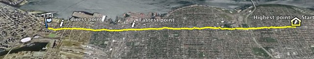
- I can't take photos at all while tracking my movements with Sports Tracker, though that application is cool, giving you graphs of speed and altitude over time, exporting into multiple formats so that you can, for example, display them on Google Earth
- everything's faster and better than my regular luxury phone, the Nokia N70
- absent a data plan, having wi-fi that works on my phone rocks compared to not being able to get instructions to share an internet connection with an N70 working
- vibrating when turning the thing on scares the crap out of me
Rebecca started things off accurately calling the research project a 'taste test', and has been posting photos of her travels around the Vancouver area. If it wasn't for Roland, I'd be using about half of the functionality that I'm currently using. He has his first day Blink! reaction and sober second day thoughts. I'm looking forward to hearing from Kris and Dave, who are most likely to document with video.


nice!
Thanks! Not going to take photos often on my bike route, though. Too tempting to pay attention to the photo I take, taking attention away from the road. I don't know how you do it!
I'm totally fine with logging my route and making fun Google Earth maps out of them though! :)
all you need is a strap on your phone to take pics!
i have a strap if you need one!
You would Roland :)
nice one on the google map
Hi, it's weird how paths cross and recross across the blogosphere and the device-o-sphere. I seem to hit your blog or your photos every once in a while. I'm the admin for a group called Commute Maps, and I'd love to have your photo added to the group.
A group for people mapping out their mundane routine? Count me in!
This is fascinating; I've just ordered a DG-100 and can't wait to get this going. It's something I've often considered doing.
Is there a way to export the data to something such as Google Maps etc and make a publicly-viewable map of your route?
Yes, the DG-100 comes with a CD-ROM that has a Windows application to export KML and other formats. If you have a Mac, you'll need to follow Jaako's slightly convoluted instructions to get it working (it's not his fault, it's not yet trivial to get the data when using a Mac).
The above comments will not display in the recently updated section because they are syndicated directly from the Flickr photo.