
My Bike Commute is 10.8 KM One Way, 8.5 the Other Way
Posted by Richard on Monday, 17 September 2007You know how people exaggerate the olden days by saying they had to walk to school uphill both ways? Well my biking commute is almost like that: on the way to work it's downhill most of the way save for an uphill climb at Lakewood Drive, where on the way back it's uphill approaching Commercial, then downhill after Renfrew and then back uphill, then, saving the worst for last, a steep uphill climb at Boundary and Union in Burnaby. Like Roland, I drew my bike route on Google Maps, but I drew both my to and from work routes. (To work is in red, from work is in blue.) According to Google Calculator, my commute to work is 10.8 KM, and 8.5 KM back home. (I typed in "6.71 miles in kilometers" and "5.31 miles in kilometers" and rounded off the answers.) Because there are more hills on the shorter route, both directions take about the same time, from 45 minutes to an hour each. Two Google maps after the break.
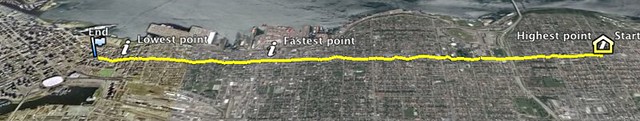
As you can see, the route to work takes me next to Burrard Inlet and underneath the Second Narrows Bridge, technically over the train bridge and under the road bridge. It therefore takes me near boats and trains, and sometimes big ocean liners.
Those serious about biking should pick up the paper copy of the TransLink biking map. It's very detailed, with many types of bike routes—on street, off street, and alternate routes, with hills and caution areas noted.
nice!
Thanks! Not going to take photos often on my bike route, though. Too tempting to pay attention to the photo I take, taking attention away from the road. I don't know how you do it!
I'm totally fine with logging my route and making fun Google Earth maps out of them though! :)
all you need is a strap on your phone to take pics!
i have a strap if you need one!
You would Roland :)
nice one on the google map
Hi, it's weird how paths cross and recross across the blogosphere and the device-o-sphere. I seem to hit your blog or your photos every once in a while. I'm the admin for a group called Commute Maps, and I'd love to have your photo added to the group.
A group for people mapping out their mundane routine? Count me in!
This is fascinating; I've just ordered a DG-100 and can't wait to get this going. It's something I've often considered doing.
Is there a way to export the data to something such as Google Maps etc and make a publicly-viewable map of your route?
Yes, the DG-100 comes with a CD-ROM that has a Windows application to export KML and other formats. If you have a Mac, you'll need to follow Jaako's slightly convoluted instructions to get it working (it's not his fault, it's not yet trivial to get the data when using a Mac).
The above comments will not display in the recently updated section because they are syndicated directly from the Flickr photo.